Saturday, January 28, 2012

MAGNETIC COMPASS

Introduction:
                                A compass is a navigational instrument that measures directions in a frame of reference that is stationary relative to the surface of the earth.


Description:
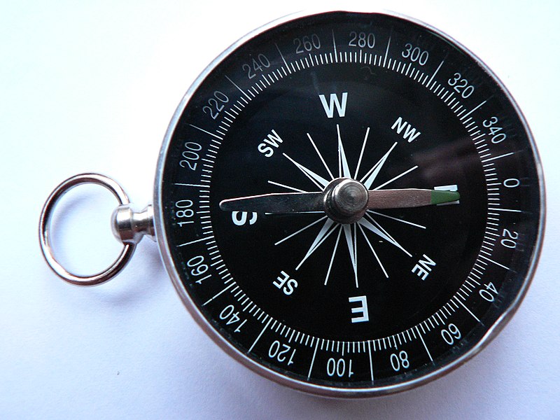
                               The frame of reference defines the four cardinal directions (or points) – north, south, east, and west. Intermediate directions are also defined. Usually, a diagram called a compass rose, which shows the directions (with their names usually abbreviated to initials), is marked on the compass. When the compass is in use, the rose is aligned with the real directions in the frame of reference, so, for example, the "N" mark on the rose really points to the north. Frequently, in addition to the rose or sometimes instead of it, angle markings in degrees are shown on the compass. North corresponds to zero degrees, and the angles increase clockwise, so east is 90 degrees, south is 180, and west is 270. These numbers allow the compass to show azimuths or bearings which are commonly stated in this notation.

Types of compass:
1.There are two widely used and radically different types of compass. The magnetic compass contains a magnet that interacts with the earth's magnaetic field and aligns itself to point to the magnetic poles.
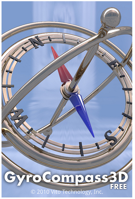
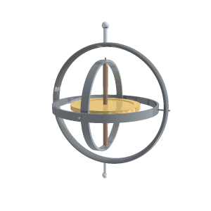
2.The gyro compass (sometimes spelled with a hyphen, or as one word) contains a rapidly spinning wheel whose rotation interacts dynamically with the rotation of the earth so as to make the wheel precess, losing energy to friction until its axis of rotation is parallel with the earth's.


Reference:
1. wikipedia.org
2. google images

SEXTANT

Introduction:
                                 A sextant is an instrument used to measure the angle between any two visible objects. Its primary use is to determine the angle between a celestial object and the horizon which is known as the altitude.


Description:
                               Making this measurement is known as sighting the object, shooting the object, or taking a sight and it is an essential part of celestial navigation. The angle, and the time when it was measured, can be used to calculate a position line on a nautical or aeronautical chart.Since the sextant can be used to measure the angle between any two objects, it can be held horizontally to measure the angle between any two landmarks which will allow for calculation of a position on a chart.

MAN USING A SEXTANT


MARINE SEXTANT


 Using the sextant to measure the altitude of the Sun above the horizon
 REFERENCE:
                       1. wikipedia.org
                       2. google images

ARABIAN KAMAL

Introduction:              
                       A kamal is a celestial navigation device that determines latitude. The invention of the kamal allowed for the earliest known latitude sailing and was thus the earliest step towards the use of quantitative methods in navigation. It originated with Arab navigators of the late 9th century and was employed 
in the indian ocean ffrom 10th century. 


Description:
                      It consists of a small board with a knotted piece of twine through the center. The observer holds one of the knots in his mouth and extends the board away so that the edges make a constant angle with his eyes. 


Reference:
                  1. wikipedia.org
                  2. google images 

GYROCOMPASS

Introduction:
                        A compass with a motorized gyroscope whose angular momentum interacts with the force produced by the earth's rotation to maintain a north-south orientation of the gyroscopic spin axis, thereby providing a stable directional reference.
 

Description:                                     
                             A gyrocompass­ (less often spelled gyro-compass­ or gyro compass​) is a type of non-magnetic compass which is based on a fast-spinning disc and rotation of our planet to automatically find geographical direction. Although one important components of a gyrocompass is a gyroscpe, these are not the same devices; a gyrocompass is built to use the effect of gyroscopic precession, which is a distinctive aspect of the general gyroscopic effect. Gyrocompasses are widely used for navigation on ships, because they have two significant advantages over magnetic compass.
1.They find true north as determined by Earth's rotation, which is different from, and navigationally more useful than, magnetic north and
2.They are un affected by ferromagnetic materials,such as ship's steel hull, which change the magnetic field.


Click on the below links for blogs on corresponding topic:

Gyroscope
Marine Chronometer
The Mariners astrolabe
Speedometer used in vehicle
Odometer

GYROSCOPE

Introduction:
                       A gyroscope is a device for measuring or maintaining orientation, based on the principles of angilar momentum.

Description:
                              In essence, a mechanical gyroscope is a spinning wheel or disk whose axle is free to take any orientation. Although this orientation does not remain fixed, it changes in response to an external torque much less and in a different direction than it would without the large angular momentum associated with the disk's high rate of spin and moment of inertia. Since external torque is minimized by mounting the device in gimbals, its orientation remains nearly fixed, regardless of any motion of the platform on which it is mounted.  
                             

Applications:
                      Applications of gyroscopes include inertial navigation systems where magnetic compasses would not work (as in the Hubble telescope) or would not be precise enough (as in ICMBs), or for the stabilization of flying vehicles like radio-controlled helicopters or unmanned aerial vehicles. Due to their precision, gyroscopes are also used to maintain direction in tunnel mining.   


A gyroscope in operation with freedom in all three axes. The rotor will maintain its spin axis direction regardless of the orientation of the outer frame.


Reference:
                  1.wikpedia.org
                  2.google images    


Thursday, January 26, 2012

MARINE CHRONOMETER

Introduction:
                                  A marine chronometer is a clock that is precise and accurate enough to be used as a portable time standard it can therefore be used to determine longitude by means of celestial navigation.
Description:        
                     To determine a position on the Earth's surface, it is necessary and sufficient to know the latitude longitude and altitude. Navigators could determine their latitude by measuring the sun's angle at noon.The purpose of a chronometer is to measure accurately the time of a known fixed location.       
    

First marine chronometer


The modern chronometer


Mechanical chronometers

 Reference:

1.wikipedia.org

2.google images


The Mariner's Astrolabe

Introduction:
                      The Mariner's Astrolabe was used to determine the latitude of a ship at sea by measuring the noon altitude of the Sun or the meridian altitude of a star of known declination.
 How it is used ?                              
          It was not possible to determine longitude at sea in the early days of transoceanic navigation, but it was quite easy to determine latitude. To go to a place of known latitude, the ship was sailed to that latitude and then sailed east or west along the latitude line until the place was reached. To find the latitude of the ship at sea, the noon altitude of the Sun was measured during the day or the altitude of a star of known declination was measured when it was on the meridian (due north or south) at night. The Sun's or star's declination for the date was looked up in an almanac. The latitude is then 90° - measured altitude + declination . The Mariner's Astrolabe, which was popular in the late 15th and early 16th centuries, was a simple brass ring, graduated in degrees with a rotating alidade for sighting the Sun or a star. The ring was cast brass, quite heavy and cut away to keep it from blowing around in the wind. It was not a very good instrument and errors of four or five degrees were common.

 It should be noted that any instrument used to measure altitudes above the horizon can be called an astrolabe.


The mariner's astrolabe in the template is shown below:
[Mariner's 
Astrolabe Template]
 Reference: http://www.astrolabes.org/mariner.htm

speedometer used in vehicles

Introduction:
                     A speedometer is a gauge that measures and displays the instantaneous speed of a land vehicle. Now universally fitted to motor vehicles.Speedometers for other vehicles have specific names and use other means of sensing speed. For a boat, this is a pit log. For an aircraft, this is an airspeed indicator. The speedometer was invented by the Croatian Josip Belušić[citation needed] in 1888, and was originally called a velocimeter
Principle of operation:
There are three types of spedometeroperations
1.Eddy current operation
2.Electronic operation
3.Bicycle speedometer operation

GPS:
               GPS devices are positional speedometers, based on how far the receiver has moved since the last measurement.


Friday, January 20, 2012

odometer used in navigation


Odometer
Introduction:
                    An odometer or odograph is an instrument that indicates distance traveled by a vehicle, such as a bicycle or automobile. The device may be electronic, mechanical, or a combination of two. The word derives from the Greek words hodos ("path" or "gateway") and metron ("measure").
                                                         
                                                            MECHANICAL ODOMETER


Principle of operation:
                Odometer works by measuring number of rotations of a wheel or fan whose rate of rotation depends on the speed of the vehicle.


Types of Odometers:
               There are two types of Odometers used. Digital meter which is using now-a-days and mechanical odometer which is used in olden days and the benefit of using mechanical odometer is we can reset the reading of mechanical odometer by rotating the wheel  of the automobile in the opposite direction to the actual wheel rotating direction of the vehicle.The reading in the mechanical odometer will last up to 999999.9 and after that again the odometer gets reseted to zero, where as in digital odometer it can go more than 999999.9 and the digital odometer cannot  be reseted. 


                                                                                 ODOMETER OF AN VEHICLES
                                                           
                                                                                          Digital odometer

Tripometer:
                   There is a trip odometer present both in mechanical and digital odometers, which give the information about the distance traveled by the vehicle for a particular trip. We can reset the trip odometer to zero after completing the trip.


Other devices used as odometer:
        Recently GPS(Global positioning System) is also used as odometer and it is also very accurate.
                                          
                                                    GPS RECEIVER AS AN ODOMETER
References:


1. How stuff works
2.wise geeks3.Wikipedia4.google images